
On October 8, 2016 the Amabel Property Owners Association organized a meeting of residents to talk about the Sauble Land Claim. At that meeting I showed a picture of an 1855 draft map, made by surveyor Charles Rankin, of Amabel township, the Saugeen Reserve, and the Chief’s point reserve. I also showed on the map what appears to be a post, along with the notation “NE < Ind. Res.”.
David Dobson had earlier come up with a theory of the meaning of the notation “NE < Ind. Res.”.
At the October 8 meeting I showed how I believed Mr. Dobson’s theory was flawed.
My powerpoint presentation, including my critique of Mr. Dobson’s theory, was posted to:
Mr. Dobson reviewed my presentation and took offence, posting on his blog a reply to my critique of his theory:
http://saublelandclaim.blogspot.ca/2016/10/lets-set-record-straight-or-pissing.html
A long discussion followed in the form of comments to the posting, with two anonymous commenters , AM and AG, joining in.
I determined that I needed to use drawings and pictures to carry on the dialogue, so I am posting this on my own blog at:
(with a link posted on David’s blog that directs to mine).
There are three or four theories being put forward by Mr. Dobson and AM regarding the “NE < Ind. Res.” notation.
Theory 1
The first theory by Mr. Dobson is that the “NE <” in the notation refers to the NE direction of the east boundary of the chief’s point reserve. This has been disputed by me and apparently also by AM on the grounds that the direction of the chief’s point east boundary is north westerly, definitely not northeast or north easterly. Mr. Dobson has conceded that he erred and that theory 1 is incorrect.
Theory 2
The second theory is by AM (who is anonymous), who said:
At that notation marker if you draw a cross on the page at 90 degrees to the page (which is how you calculate bearing directions) you will find that that extension line “construction line” which passes through the marker termed “N.E < Ind. Res.” actually runs in the North Easterly direction from that cross. Merely to describe this line Mr. Rankin termed it as such on this working draft copy because in fact this line runs coincident with the Saugeen Easterly boundary that ends at Main St.
The “notation marker” is the “NE < Ind. Res.” printed on Rankin’s draft map of October 12, 1855.
Contrary to AM, drawing “a cross on the page at 90 degrees to the page“ is not how bearing directions are calculated. The edge of the page is not a reference for Rankin’s lines and the edge of a page is rarely a reference for any survey map or plan. Contrary to Mr. Dobson and AM, the edge of the page is not an indicator of true north. Rankin would never have made such a huge mistake as to say that the “extension line “construction line”” which passes through the marker termed “N.E < Ind. Res.” actually runs in the North Easterly direction”. The extension line in fact does not run north easterly from any point on the map. It is not plausible that Rankin would term the direction of the “construction line” as “NE”. AM erred in assuming that the construction line ran north easterly and erred in assuming that Rankin saw the construction line as running North easterly. The error is fatal to the AM theory.
AM then says:
This line then is projected N.E. and used to intersect with the extension of the easterly boundary on Chief’s point lands which it extends right though the Sauble River, This is how that bearing of N 13 deg. W is established and as shown for the bearing of the Easterly Boundary Line on Chiefs point.
That “N.E < Ind. Res.” marker was simply a way to relate the 2 separate reserve easterly boundaries together – that’s all.
Contrary to AM the construction line is not projected N.E. and cannot be projected N.E. because it does not run N.E. But the construction line when projected does intersect the southerly extension of the eastern boundary of the Chief’s point reserve. And the two lines do form an angle (as any two non-parallel lines will where they intersect).
But surveyors put bearings and distances on maps, not angles. The “N 13 ° W” on the chief’s point eastern boundary as on Rankin’s final map of 1856 is a bearing, not an angle. It is a notation to describe the direction or bearing of a line, not the relationship between two lines. If Rankin wished to describe an angle, which would be unnecessary and highly unlikely, he would describe it as just as “13 degrees” (13°) and he would mark it as 13 ° as in the drawing below.
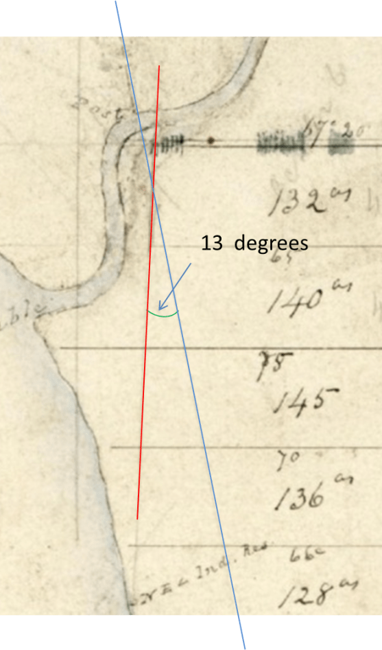
Rankin did not put the 13 degrees on the map where AM says the angle is. It just is not there. If Rankin wanted to indicate an angle on the map formed by the intersections of the chief’s point boundary extended southeastward and the Saugeen boundary extended northward, he would have put the notation “13 degrees” at the intersection. He did not put anything at the intersection. He did not put “13 degrees” anywhere to refer to that angle.
The assumption that “<” refers to the angle made by the two eastern boundaries is unsupportable. The assumption is a second fatal flaw in the theory. The notation “NE < Ind. Res.” does not describe the angle formed by the two boundaries.
The theory was already dead, but that second fatal flaw makes sure.
Theory 3
The third theory is what I will call the Dobson / AM theory which is slightly different from the AM theory. If anyone prefers to think of it as AM’s theory explained differently that’s fine – my critique applies just the same.
Here is how Mr. Dobson describes theory three:
The post at midpoint lot 31 represents where the True North line first meets land after extending through the water of Lake Huron from the termination of the Saugeen Reserve at Main Street. At this point he [Rankin] indicated, by way of notation, that True North ran in a north to east direction in relation to the page. To understand this you need to place a directional crosshair at the post to show how NSE and W are represented on the page.
The vertical arm of AM’s “crosshairs” is parallel to the edge of the page.
Mr. Dobson drew these “crosshairs” like this (solid blue lines):
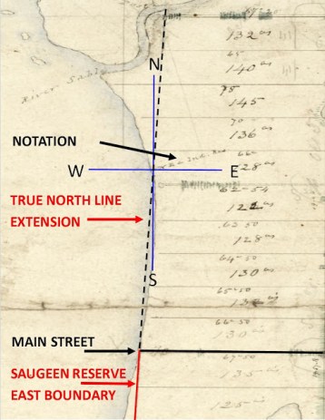
But the edge of the page does not run north-south true. Mr. Dobson’s (and AM’s) crosshairs are wrong. AM’s statement that “True North [runs] in a north to east direction in relation to the page” is not only false, but also nonsensical. True North may run in a direction slightly off vertical of the edge of the page, but the north line does not and cannot run northeast in relation to anything. A True north line runs North, period. So the explanation cannot account for the “NE” in “NE < Ind. Res” notation, because there is nothing northeast about the true north line, crosshairs notwithstanding, edge of page notwithstanding.
Then according to AM the theory goes:
The NE < Ind. Res. notation marks the True North extension line to the mid lot 31 post in relation to the Saugeen Eastern boundary and also the direction True North runs from the mid lot 31 post to the Sauble River in relation to the page.
This is Ok except for “in relation to the page”, because as argued above, the edge of the page is not North true, and the edge of the page is completely irrelevant.
Then the theory goes:
Rankin was using this map to help in calculating the directional bearing of Chief’s Point eastern boundary. To prove this, the map shows that he first calculated the bearing by using north as it is presented on a page; straight up and down, which gave him a rough idea of the direction bearing
Contrary to AM, North is not presented on the page as straight up and down.
Then the theory goes:
If you look closely enough you can actually see it written down on the map and the straight construction line from the top of the page which helped him calculate this angle. The bearing is shown as N 11° W.
I agree that N 11° W is a “bearing” (or direction), not an angle. But it is not a “rough idea of the direction bearing”.
Magnetic is related to true by “variation”
Magnetic direction is different than true direction (astronomical direction). Magnetic direction is related to true direction by “variation”.
Rankin used mostly true direction, but on the draft map he uses magnetic direction at least twice.
One is the top boundary of Amabel township, where he writes “east by needle”, which means east magnetic or 90 degrees magnetic.
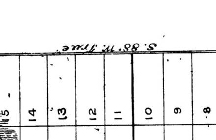
But on the final map he defines the direction as S 88 deg W TRUE. Which is the same as 88 deg True, just named in the opposite direction.
Rankin measured the variation and logged it in his field notes as 2 degrees west. The same is on each page of the field notes.
For west variation, magnetic = true plus variation
Magnetic bearing = 88 ° plus 2° = 90° magnetic. “East by the needle” and “S 88° W True” are exactly the same line, only specified as opposite directions. The final map direction is not a correction of the draft map direction.
For the traverse of the eastern boundary of the chief’s point reserve, field notes page 146, October 8, 1855, Rankin clearly indicates the astronomical direction (not the angle) as N 13 degrees West”.
This means N 13 degrees west true, which is the same as 347 degrees true (360 minus 13 = 347).
When variation is westerly the formula is:
magnetic = astronomical plus variation
So the magnetic direction equivalent to 347 degrees true (N 13 deg w true) is 347 +2 = 349 degrees magnetic which is N 11 degrees west magnetic (360 minus 11 = 349)
N 13 degrees w true and N 11 deg w magnetic are exactly the same direction. That Rankin labelled the direction (not the angle) N 11 degrees west on his draft map of October 12, 1855 and labelled the same line 13 degrees west true in his field notes and on the final map of 1856 means nothing.
Contrary to Mr. Dobbins, the 11 deg on the draft map was not an error.
The word “true” on the final 1856 map does not indicate a correction of an error. “True” means “astronomical”, not “corrected”.
David said:
To show this is what he [Rankin] did, the bearing from the 1855 map of N 11° W is incorrect and the actual bearing correction of N 13° W True can be seen on the official map of 1856. The working copy does not use the word “True” in the bearing description.
Of course the working copy did not use the word “true”. Because the bearing was magnetic, not true.
Theory number three fails too.
Theory 4
Theory number 4 is the second Dobson theory:
I put forth the possibility that the notation is identifying the two lines as a statement. NE < = True North extension line and Ind. Res. = Chief’s Point extension line. Therefore the notation would read North Extension Angle Indian Reserve. What makes me think this is that the angle that produces the N 13° W True calculation is so pronounced on the page it just seems like an obvious conclusion. Also, the notation spreads across the span of the 13° angle. This makes it difficult for me to believe that this is a coincidence.
I believe this is the same as the Dobson /AM theory, but that makes no difference.
It fails for reasons above. It would be very unusual for Rankin to put an angle on a map, and if he did he would put a number in only (not a direction) and he would put the number right in the intersection as in the drawing above.
I agree that NE means Northern extension, but < does not mean “angle”.
The theory fails.
As one writer, a surveyor, put it:
The notation < means that this is the direction or angle of the line that has to be followed south to get to the boundary.
Craig

Mr. Gammie.. lol.. where is the the 2nd reference to Mag other than “East by needle”.. and if you have found that.. can you explain the significance of it?
And tell me how it is applied to the rough plan
Thanks
Benny: There are at least two other magnetic direction on Rankin’s draft map. N 11 deg W on the eastern boundary of chief’s point reserve. On the line along north part of chief’s point is S 68 1/2 deg E. Both are magnetic. There is no significance. Final maps must be only true bearings. Traverses on the ground are done with magnetic bearings. It is no surprise that both magnetic and true show up on the draft map.
Craig
Oh is that all? Thats what i thought.
What makes you so certain that the varience was as 2 west other than documented on field diary notes top line of all entries?
Ben:
Every page of Rankin’s field notes say variation 2 degrees West.
It’s “variation” – not “variance”. Variance is completely different.
Somewher in journal he indicates which days he determined variation.
I appreciaate your interest.
Craig
Big time significance. Mag is coincendent with the page as a reference… which explains post notation.
Rubbish. You have never seen the edge of the page. I have. The edges were cropped out when the map was scanned. If the real edge of the page was magnetic north in 1855, it would have been pure coincidence. Rankin’s reference line on the map was one of the lines on the map labelled with a true bearing. My guess is the east boundary of Amabel. The post notation has nothing to do with any bearing, true or magnetic.
Craig
Craig you actually contradict yourself by you the surveyer statement … he says direction or angle?? But you say
> does not mean “angle”.. so which is it??? Lol
Benny:
The surveyor said: “The notation < means that this is the direction or angle of the line that has to be followed south to get to the boundary." From the context and the words it is clear he is talking about the direction to be followed south to get to the Saugeen Reserve, not the chief's point reserve. When the surveyor says "angle" he means direction. That is different than an angle meaning the number of degrees formed by the intersection of two lines. If he were referring to the angle in degrees formed by intersection he would have said "angle of the two lines" rather than "angle of the line". Why he added "or angle" when he had already said "direction" I don't know.
The surveyor does not contradict anything I said.
Craig
But he states or angle? Means angle to me? Are you ignoring that? You quoted it mr. Gammie??
Thank you for correcting me Mr Gammie – it is also Mag. declination? Same thing right, or are you going to argue that maybe?
Mag declination is not a term I am familiar with. I don’t use the term declination as a synonym for variation.
Craig
I suppose it could also mean greater or less than too right????
as stated, “angle” seems to be ambiguous to some. He clearly said angle meaning direction. I did not see any ambiguity when I quoted him.
Less that or more than does not make any sense in the context of NE < Ind. Res.
You've read all the theories. What do you think?
Craig
You should be familiar with the term as it exactly means varience same thing.. lol
As stated, declination is not “variance”. I am familiar with the term declination, and I am aware that some use it as a synonym for variation. I prefer not to use the term declination that way. It is all totally irrelevant to the discussion of “NE < Ind. Res." anyway.
Yes, and Mr. Dobson’s blog and i am really leaning toward A.M.’s theory.. it cannot be wrong and quite frankly makes absolute sense…unless of course the only person Rankin himself can prove his work otherwise. But as it looks it really looks good.
AM’s theory is founded on assumption that the edge of page is true north / south, which is clearly a false assumption.
How do you get around that?
Craig
That’s not what i read. Your summery of that is explanation is completely wrong.
One could actually see that the SOFN runs north east from from your Mag. Explnation… you see Gammie.. true north runs at a N.E. < "angle or direction" from Mag… which is westerly from astro True… lol the end notation refers to … Ind. Res…. where is that angle coming from???? SOFN below main…lol
A.M. did not refer to the top of the page as astro…
I did not say that AM refereed to the “top of the page as astro..”
Here is what AM actually said:
“At that notation marker if you draw a cross on the page at 90 degrees to the page (which is how you calculate bearing directions) you will find that that extension line “construction line” which passes through the marker termed “N.E < Ind. Res.” actually runs in the North Easterly direction from that cross. "
AM assumed the side of the page runs true north south. That assumption is false. AM assumed that you calculate bearings using the edge of the page as a true north referece. That assumption is also false. I have yet to find a plan of survey, aviation chart, or nautical chart in which the edge of page runs true north and south. Even the few topographical maps I have do not have the edge of the page running true north south.
Besides, the digital scan of the Rankin draft map does not show the edge of the page. I know this because I commissioned the digital scan (that everyone is using) from the original map, and I know there was no effort to make sure that the edge of the page was exactly lined up parallel to the edge of the digital scan. To use the edge of the original map as true north is wrong. To use the edge of the digital scan is even worse.
You and AM and Mr. Dobson are novices. There is nothing wrong with being novices. But there can be a problem if a novice claims to be an expert. If the ship's navigator assumes that the edge of the nautical chart is due north, there's a better than even chance that the ship will be lost at sea. And I would not want to fly around mountains with a novice at the navigator's table.
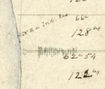
"NE Ind. Res." means Northern Extension of the Saugeen Reserve Eastern Boundary.
"<" is rankin's shorthand to himself of "over there, just to the left of this notation, is the Northern Extension of the Saugeen Reserve Eastern Boundary, with the dot showing the zero chains point of the traverse southward on that "extension"and later (at 115 chains) the reserve boundary itself.
It is a challenge to have this discussion on a blog without the benefit of drawings and real maps.
I have indicated that I will repeat my October 8th presentation/discussion for individuals or small gruoups anytime. I will even let Doug Jordan attend if he promises not to disrupt and ruin it for others. The offer is hereby extended to you Ben.
Craig
SOFN boundary runs 0 degrees true, it runs 2 degrees magnetic. You could say it runs in a northerly direction. But the boundary does not run northeast or northeasterly. It is false to say it does.
There is no angle. The < does not refer to angle in the sense of degrees formed by intersection of two non-parallel lines. It does not mean angle at all.
The notation is Rankin's note to himself. We should not look at it as having a clear meaning to others. We have made a lot of progress getting Mr. Dobson to believe that NE means "Northern Extension" instead of his earlier "Northeastern". Let's build on that.
I'm going off-air until tomorrow.
Craig
Basically he says the line that represents North runs N.E. With respect to the post wich also is with respect to Mag. .. that’s what i understood and makes complete sense with its notation on the rough plan complete with its construction lines.
a line that runs true north cannot run northeast. true north is zero degrees true. For rankin true north was also 2 degrees magnetic. northeast is 45 degrees true. For rankin northeast true was 47 degrees magnetic. 2 degrees magnetic and 47 degrees magnetic are clearly different directions. true north does not run true northeast. magnetic north does not run magnetic northeast. Angle formed with the edge of the page is irrelevant.
Craig
That is wrong… if you say mag runs west from the true than it must run east of it? Not to hard to see.. draw mag as a vector… than true as a vector from it? … can you agree that true will run in a N.E. < from the mag vector? Just saying??
I did not say magnetic runs west from the true north. Look at your statement ” mag runs west from the true than it must run east of it”. The stement is absurd. The word \”vector just confuses the issue. I use the term “bearing” or “heading”. And no true does not “run in a N.E. < from the mag vector?"
There is no such thing as a North east angle. Northeast is a bearing.
Craig
If you do not see that declination and variance means the exact same thing than i now see how much knowledge you have on this subject, which further shows how you understand any type of survey concept, or the methodical process/ investigation thats involved. No prob Craig, i have said enough, cheers.
Declination and variance are not the same. Declination is commonly used as a synonym for variation. I do not use it that way , but I fully understand those who do. In your attempt to show my lack of knowledge “on this subject”, you have only demonstrated your own lack of knowledge. My mariner’s navigation handbook is out on loan right now, but when it returns I would be happy to lend it to you.
Craig
No thanks – i don’t need a “handbook”… lol
I use a very highly reputable textbook…
https://www.mheducation.ca/highereducation/products/9780070159143/
This is not a handbook, Craig
On what page of your reference book does it say that the edge of the map is always due north?
What page talks about “variance”?
What page says variance and declination are the same?
What page indicates that a direction of 2 degrees magnetic is Northeast?
Over and over you have demonstrated how poorly you understand anything to do with surveying. I doubt if you really have the book.
Craig
On what page of your reference book does it say that the edge of the map is always due north?
*****None, your misinterpretation
What page talks about “variance”?
*****Page 277
What page says variance and declination are the same?
*****Page 277
What page indicates that a direction of 2 degrees magnetic is Northeast?
*****None, your misinterpretation
Over and over you have demonstrated how poorly you understand anything to do with surveying. I doubt if you really have the book.
*****Yes i do have the textbook, read it cover to cover…
This book also helps to understand that in Spherical Geometry – much tougher to understand and it took alot of work to grasp but what i do know is this
In sphereical geometry Parallel lines DO NOT EXIST
Thanks Craig – its been a blast on here commenting…Good Luck!
Benny:
We are dealing with two dimensional maps. Spherical geometry has no application here.
I have an engineering degree and many years of experience. Do you really think you can put one over on me in the field of geometry?
Nice try though.
I would like to check out your reference book page 277. Maybe you could just scan page 277 and email it to me at cgammie@rogers.com
Craig
Lol. Go buy it.
What edition do you have? So I can get the correct page 277.
Craig
Craig – you do realize that the 2-D map is supposed to best reflect surfacial measurements on a spherical planet right? Or maybe you still think the earth is flat?
Humm, what is the discipline? I truly hope not Geomatics..you don’t need a scan , a simple google wiki search will describe Mag Dec or Var…however you choose to call it. Means the same thing.
What site describes variance (not variation) as declination?
Link please. Support your assertion please.
Craig
Ah i see. Now what you are caught up on. Varience is the rate of change over time… is that what you are caught up on? The Var, i meant Variation..i took for granted you understood but clearly you did not. Still does not sway anything.
Like i said Good Luck Gammie, you’ve lost my vote!
Cheers!
It was your gross misuse of scientific and mathematical terms and your inability to back up your assertions that gave you away.
Good luck Charlie. You’ll never get my vote.
What is your Eng Background… and are you praticing now? … please answer Gammie so we all know.
Benny:
1974 University of Waterloo Faculty of Engineering Bachelor of Applied Science. This is an accredited engineering professional program. I am still an engineer, I always will be an engineer, and I am fully qualified to get licenced and resume practicing engineering, if I should ever decide to do so.
That I currently do not offer engineering services and that am currently not licenced to practice are irrelevant.
Regarding the “NE < Ind. Res.” notation, my assertion that your theories and Dobson’s theories and AM’s theories are critically flawed is based on facts and argument rather than relying on my credentials, or on my engineering degree or on my former professional license.
I have only relied on my engineering education and experience to support my claim that you are a charlatan.
Craig
Ah, is that the only mag bearings on the rough plan?
On the 1855 rough map:
North border of amabel is magnetic (east by needle)
Chief’s point reserve eastern boundary is magnetic (N 11 deg W)
There is a line across the top of chief’s point that says “S 68 ½ deg E”. I think it is magnetic
A bearing on highway 20 that says “N 76 deg 15 min E” I think is true but not sure.
All other that I have found are true.
On the final map all bearings are true. Magnetic is not used in final maps.
The draft map bearing on highway 20 that says “N 76 deg 15 min E” is true.
So you think that the “E.” In the notation means “Extension” Craig,
I believe that NE means Northern Extension of the Eastern Boundary of the Saugeen reserve.
How can the “E” accompanied directly after an “N” in the notation refer to that?
In my mapping experience, to create an Acronym that depicts that, is completely absurd.
A professional like rankin, one would’ve expected a CLEAR representation of that… ie. Ext. or simply Ex. Would suffice as to not confuse a reader with a potential meaning of “East” on a Map.
What is your thought on the Meaning of the “N”, surely one expects North, but you may have a different thought?
That theory is very critically flawed,
as to your assumption of a capital E… on a map means “extension”…
The map of 1855 was Rankin’s rough map. It included many of his notes to himself. I doubt if he expected that 160 years later people would be debating the meaning of his shorthand notes to himself.
I have done some serious sailing. On most trips I was the navigator. I made many notes to myself on my charts (maps). As I look at some old charts I find notations in my hand and I have no idea what they mean. They were just notes to myself. I knew what they meant at the time, and that’s all that was needed.
Same with Rankin’s draft map. It is full of lines, additions, notations that were I am sure clear to him, but without context may mean little to us.
Northern Extension is plausible and is consistent with all the other evidence.
As I have demonstrated, the SFN theory, David Dobson’s Theory, and AM’s theory are critically flawed. For reasons I have laid out elsewhere.
Craig
The theory of yours Gammie – that you said “Extension” is extremely and very critically flawed, because it is easily dismantled. I just did it.
And please don’t say “means little to us”… to you maybe but not us…I understand.
The same “E” actually appears in bearing notations weather from true, mag, page North or even grid north. And it resembles the exact same typography as he uses in bearing notations on the draft. Can you tell me Why? The same E?? One distinctly means East and the other… as you say ….Extension. What is most logical.
Saying Extension is total inference.. no weight…made up… .. E means “East” Simple
Northern Extention is NOT plausible..and NOT consistent at all with any evidence.. unless of course you have proof of the word “extension” used in his diary, field notes, or rough draft. If so than please share.
If you cannot see that, i cannot help you.
I don’t care about your Navigation techniques. What the heck does that have to do with anything…Craig, do you have any reasonable explanation as to why he would provide such an “extention” of that line for all of us to see? What is it’s purpose..is the real question..from what i can understand in Mr. Dobson’s throrough explanations… they are sound. A.M’s is very, very appealing.
To infer the E has a meaning of “extension” with nothing to back it up other than siting a personal experience is simply not good enough. especially on a map with bearings that are associated with the same typographic “E”, an Extension meaning is absolutly ridiculous, and quite frankly with what you described in a previous post.. your credentials.. this disturbs me, as you being a councillor representing Sauble Beach.
Now, from i read in the press, i see why Janice and the rest council shuts you out.
Good Bye, and good luck to you.
The extension is on the draft map because Rankin and crew traversed it following a compass course of 182 degrees, laying chains all the way to what is now highway 21 (at 709.5 chains), and recording landmarks along the way.
Rankin’s journal page 16:
Sept. 4, 1855 1 day surveyed, 177 chains: “Continued the traverse from the mouth of the au Sable to the contin of the Indian Boundary ….”
“continuation of the Indian Boundary” is pretty close to “Northern Extension of the Indian Boundary”.
From my Oct 8 presentation re Rankin’s field notes:
Rankin was required to record all monuments and boundaries in the traverses in his field notes. Yet he did not even mention the post in his
notes on the traverse south to the post and south from the post.
The inescapable conclusion is that the post did not mark anything, not a terminus, not a boundary.
It was just a sighting post in the traverse south.
It could have been placed anywhere between the river and main street on the extension of the boundary.
The post has no significance.
“Northern Extension” makes lots of sense. You should have a look at the presentation and listen to the audio recording.
You did not “dismantle” my theory. You contradicted it, but that is not dismantling.
Dobson’s theory characterized a line running northwesterly as “Northeast”, clearly critically flawed , and since abandoned by Dobson.
AM’s theory had the edge of the map, which AM could not see, running true North and had the real true north line running northeasterly, clearly critically flawed.
No council member represents just Sauble Beach residents.
What is it about my credentials that disturbs you?
What did you read in the press?
Why do you think the rest of council tries to shut me out?
Craig
What came first? Rough plan or field work?
I would guess that the map came first, but without a lot of detail. Then I expect the drat map was filled in as the work in the field progressed.
So for example if i found the bearing N 76 E by your inference of what E means i could actually say it means N 76 extension… to describe the particular bearing on the plan.. i mean that’s what you say E’s are … but the fact that the E’s are exactly the same typography, you are incorrect.
How do you get around that?
It’s absurd. It’s especially damaging to your theory Craig. Easily Dismantled! Not a contridiction.
Benny:
I draw no such inference from “N 76 E”. The E in “N 76 E” clearly means East. That does not mean the “E” in NE < Ind. Res. means “East”. It simply does not follow.
Mr. Dobson started with a theory that NE meant Northeast, or more specifically Northeast bearing of the chief’s point eastern boundary. Mr. Dobson has acknowledged that his original theory was wrong. He has changed his view. He now says NE probably means Northern Extension.
Here are his words:
“I put forth the possibility that the notation is identifying the two lines as a statement. NE = True North extension line and Ind. Res. = Chief's Point extension line. Therefore the notation would read North Extension Angle Indian Reserve.”
Note Mr. “Dobson’s North Extension ..” Not “North East..”
You believe that you have dismantled my theory. In fact in your failed attempt to dismantle, you have strengthened my argument.
I would like to know what you think the three parts of the notation “NE < Ind. Res.” mean.
What do you think NE stands for?
What do you think “<” means?
Which reserve do you think “Ind. Res.” refers to (chief’s point or Saugeen)?
And I would still like to know:
What is it about my credentials that “disturbs” you?
What did you read in the press?
Why do you think the rest of council tries to shut me out?
I would also like to know if you can explain Ms. Jackson’s huge, ridiculous, malicious, obvious, whopper lie in the press about me:
"At $900 an hour we can't afford to have Coun. Gammie phoning him on a daily basis, which is what he was doing," said Jackson.
Craig
Mr Gammie
I have followed Mr. Dobson’s blog and have been interested in this argument as well. What I have noticed is three things:
* You never answer the question of why Rankin traversed from the Sauble River to Main Street only that he did. It’s obvious he did, the question is why? The northern terminus of the Saugeen Reserve is identified by the 9 1/2 mile measurement, so why the extension? He could have established the line from Main Street to highway 21 so if Chief’s Point has nothing to do with it, it doesn’t make sense for him to do the traverse.
Your explanation:
“The extension is on the draft map because Rankin and crew traversed it following a compass course of 182 degrees, laying chains all the way to what is now highway 21 (at 709.5 chains), and recording landmarks along the way.”
This does not answer the question why. Why wouldn’t he extend the line to the northern most point on the map or some other point? He extended it to the intersection of Chief’s Point eastern boundary. You have offered no answer to this question.
*You misinterpret AM’s theory. He does not say that True North runs parallel to the page, he says that True North runs on a NE angle in relation to the page or magnetic north which appear to be the same thing. Whether it is magnetic north or the page, True North runs on a NE angle from a crosshair that represents one or the other.
If it is not the same thing by how many degrees difference is there between magnetic north and the page? It could hardly be negligible. This is how you always quote AM:
“At that notation marker if you draw a cross on the page at 90 degrees to the page (which is how you calculate bearing directions) you will find that that extension line “construction line” which passes through the marker termed “N.E < Ind. Res.” actually runs in the North Easterly direction from that cross. "
"AM assumed the side of the page runs true north south. That assumption is false. AM assumed that you calculate bearings using the edge of the page as a true north reference. That assumption is also false."
You are using straw man logical fallacy tactics.
AM defined that construction line from Main Street to the Sauble River as True North so how is it that he is also defining the edge of the page as True North?? It would seem you don't have a clear understanding of AM's theory or as I said before straw man arguments.
*Rankin clearly put the construction lines on the map for a reason, but you dismiss them as irrelevant without being able to explain what they are for at all. If you can't explain what the construction lines are for, why are you berating people for their logical explanations of what they are for?
Lewis:
The Northern terminus is not necessarily determined by the 9 1/2 mile measurement. The northern terminus is defined by the place where the eastern boundary running north meets the coast. The treaty says “about 9 1/2 miles”.
I do not know why the extension is on the draft map.
I do know however that the Saugeen extension was not necessary to establish the chief’s point eastern boundary. All that was required to put the chief’s point eastern boundary line on the map and blaze a line through the bush was the starting point on the north bank of the Sauble and the bearing of the Chief’s point line and any reference line of known direction anywhere on the map.
AM said: “At that notation marker if you draw a cross on the page at 90 degrees to the page (which is how you calculate bearing directions)..”
That is not “how you calculate bearings”. The edge of the page is irrelevant. No one uses the edge of the page unless the edge of the page is clearly marked as true north south. And no one uses the edge of the page as magnetic north/south because magnetic north/ south changes over time, making magnetic bearings on maps incorrect for practical purposes after a few years. AM in putting the vertical of his cross parallel to the page is assuming that the page runs North South. Whether he meant true north south or magnetic north south doesn’t matter.
I did assume that AM was using the edge of the page as true north. I said that was an invalid assumption. His assumption is ambiguous, but I now see that he might have been saying the edge of the page is magnetic north/ south. If that was his assumption, it is just as invalid. The edge of the page is meaningless.
AM has never seen the edge of the page, and does not know where the edge of the page is, and cannot know that his cross is at “90 degrees to the page”. No one does. The side edges have been worn or torn away and lost. The digital scan of the draft map does not extend to the edges anyway. I have seen the original paper map.
So yes I may have inadvertently used a straw man argument, but it does not matter. My rebuttal is the same. Direction relative to the edge of the page is meaningless.
True or Magnetic, either way the “cross” assumption is unsupportable. So the conclusion that the extension line runs “in the North Easterly direction from that cross” is absurd and false. The line runs in a direction of about 2 degrees from AM’s cross if the cross is referenced as zero.
That’s not North East or even Northeasterly relative to the edge of the page. If the edge of the page happens to be North, then relative to the edge of the page as North, the extension would be best described as Northerly or just a tiny bit east of north.
OLS White’s 1997 tracing of Rankin’s submitted map has the eastern boundary running about 90 degrees to the left edge of the page. If AM were to put his “crosshairs” on that map with magnetic north parallel to the side edge of the page, then the Saugeen eastern boundary would run about 92 degrees to the crosshairs. You could not then say that the Saugeen eastern boundary ran in a northeasterly direction from the crosshairs or from the edge of the page. The notation cannot indicate a relationship to the edge of the page.
I think it was a mistake to call the lines “construction lines”. They could be there for any number of reasons, including refining the map coastline details, including where the line entered and exited the water. I do not find Mr. Dobson’s or Mr. AM’s explanations at all “logical”, and in fact I find them nonsensical, and I have provided reasons.
Craig
Again, I believe you misinterpret AM. I believe AM is referring to the directional cross as how you calculate bearings not the edge of the page. Whether it be magnetic, true, or edge of page is irrelevant, it is which of these three represents the directional cross that matters. In the case of the N 11° W the directional cross is magnetic north and in the case of the N 13° W true, the directional cross is true north.
AM also did not say that you needed the extension line to establish the eastern boundary of Chief’s Point. He pointed out that by extending the line a deflection angle is created which calculates the bearing of N 13° W True. Whether Rankin already knew this by the 2° variation of magnetic north is irrelevant; the fact that those two lines intersect, a deflection angle is created. There would be no reason to extend the Chief’s Point eastern boundary in a southerly direction other than to intersect the true north line. Without Rankin no one can say for sure, but to deny how seemingly obvious this is requires one to have his head in the sand. The fact that you say you don’t know what the extension line is for makes your arguments a little hard to swallow.
As you pointed out in your own experience, the NE < Ind. Res. notation could have just been a simple notation to himself that, as applied to this working draft copy, True north is running in a NE direction to magnetic north. Not really that difficult a theory to grasp.
As for the 9 1/2 mile measurement, the treaty clearly defines it as what determines the "spot on the coast" or the northern terminus.
Lewis:
You said : There would be no reason to extend the Chief’s Point eastern boundary in a southerly direction other than to intersect the true north line.“
There could be several reasons. Just because we don’t know the other reason or reasons does not mean there wasn’t any other plausible reason.
I note that the chief’s point eastern boundary extends well northward of the coast. There must have been a reason for this. Just because we don’t know the reason does not mean that there is no reason. Same with the southward extension.
You said: AM also did not say that you needed the extension line to establish the eastern boundary of Chief’s Point. He pointed out that by extending the line a deflection angle is created which calculates the bearing of N 13° W True.
The N 13° W true and the equivalent N 11° W Magnetic were probably determined well before the two lines were drawn on the map. They are in the field notes before the traverse was made. But even if they were not determined first, that is if the bearing of the chief’s point eastern boundary was determined after the line was put on the draft map, there would be no need to extend the lines to determine that N 13° W true bearing of the chief`s point eastern border line.
You say : As you pointed out in your own experience, the NE < Ind. Res. notation could have just been a simple notation to himself that, as applied to this working draft copy, True north is running in a NE direction to magnetic north.
All through the field notes there is a clear indication by Rankin that variation is 2 degrees west. That defines the relationship between magnetic and true at the time. True north did not run “in a NE direction to magnetic north`. No matter how often you or Mr. Dobson or AM or anyone else says it, in 1855 True north did not run in a NE direction to magnetic north. And it does not now. Rankin clearly knew the relationship between true and magnetic. If he were to make a notation on the map to remind himself of that relationship, (which would not be necessary or likely as he was writing it in the field notes frequently) it would be “Variation 2 ° W”, just like in the field notes, not “NE < Ind. Res.”.
You say: As for the 9 1/2 mile measurement, the treaty clearly defines it as what determines the "spot on the coast" or the northern terminus.
No, the treaty says “about”. That’s descriptive, not determinate of a particular spot.
You say: “Not really that difficult a theory to grasp“, and “but to deny how seemingly obvious this is requires one to have his head in the sand“.
I believe you just called me intellectually inferior. A bit arrogant and condescending, don`t you think?
When you go after the character of the speaker rather than try to rebut the speaker`s argument you have only made it clear that you have no rebuttal of any merit, and that you are desperate.
When I said “critically flawed” I was talking about the theories, not the theorists. Still, I am sorely tempted.
Craig
The northern extension line of Chief’s Point eastern boundary could simply be for symmetry, who knows, that’s how it appears. If his field notes are to verbalize his thinking, his draft map is to visualize his thinking. It makes sense to me that he would show those intersecting lines on a working copy.
It sounds to me that you just don’t like AM’s argument rather than having anything concrete to disprove it. Saying Rankin would have done this or he would have done that is pure conjecture on your part. It’s ok to not agree with it, but to say that it is nonsensical and absurd?? It is really neither of those things.
I don’t need or want to attack your character if that is what you are implying. I am just pointing out that there have been a lot of points made by AM that are supportable whether they fit with your understanding of surveying theory or they don’t. Since I have pointed out two ways in which you misrepresented his theory shows that your focus is only on proving him wrong. This is really what is annoying you about my comments, not that I am supposedly attacking your character.
From all your arguments I have read you still have not proven AM’s theory wrong and without Rankin’s testimony it is doubtful you can. From what I understand of this claim it would be better to hope AM is right.
Lewis:
I don’t really care how my exposure of AM’s theory sounds to you. I showed that AM’s theory is absurd and nonsensical. I showed AM’s theory to several seasoned pilots. All said his theory was absurd. AM’s theory is absurd and nonsensical. By the way, the treaty describes the N 13 deg E true line as “in a northerly direction”. Yet you and AM still want to believe that the Saugeen Eastern Boundary, which is only about 2 degrees from the reference cross, as opposed to the chief’s point 13 degrees, runs “in the North Easterly direction from that cross”. Absurd and nonsensical and completely inconsistent with Rankin’s conventions. Absurd and nonsensical is accurate. Critically flawed is accurate.
My saying that Rankin would not have used the notation to describe the relationship between true and magnetic is based on many years of navigation experience. It is not conjecture. It is yours and AM’s theories that are conjecture.
I have not misrepresented AM’s theories.
Bereft of argument with any merit, you did attack my character.
I do not care if you don’t think I showed AM’s theory to be wrong. I showed AM’s theory to be absurd, nonsensical, critically flawed.
Please comment again. Every time you comment, you give me another opportunity to show just how flawed AM’s theory is.
Craig
It is not surprising that your seasoned pilots found the argument nonsensical and absurd when you describe it the way you have been doing throughout this blog and Mr. Dobson’s. However, your Town surveyor wouldn’t think it was nonsensical or absurd since he described the exact same thing except from a different reference point (main street as opposed to the lot 31 post). Remember this?:
“The notation < means that this is the direction or angle of the line that has to be followed south to get to the boundary."
Direction or angle to what?? True North is 0°, can't be on an angle to anything (your words). Yet the surveyor clearly describes the True North line on an angle. Again, an angle to what?? Do you think his description is absurd and nonsensical as well? Do you deny that the "line" he describes as on an angle is the True North line??
You said:
"By the way, the treaty describes the N 13 deg E true line as “in a northerly direction” (I think you meant W not E)
Are you saying that Rankin dictated the wording of Treaty 72 himself?? This would be the only way that your statement has any relevance at all. The treaty doesn't even define a point to identify the northern limit of the Chief's Point eastern boundary so to vaguely describe it as a "northerly direction" makes perfect sense. It would seem from that description the actual point was determined later. Even Ballantyne refers to the 1/2 mile up the Sauble River as the SE angle of Chief's Point even though the treaty only refers to it as "northerly" (pg 14). Is Ballantyne absurd and nonsensical as well??
Here's a thought:
Why not have your seasoned pilots review AM's theory from Mr. Dobson's blog posting (not the comments section obviously) and then post their unbiased opinions that prove without a doubt that AM's theory is wrong. Perhaps you could have them give their full names and credentials as well to help with credibility. Maybe you could relay to them that the secret expert Town surveyor agrees with AM as well.
Better yet:
Why not just ask your secret expert Town surveyor what he thinks and reveal to us the way you did with his "direction or angle" opinion what the answer is? Maybe then, we could put this argument to bed forever.
Lewis:
The seasoned pilots looked at Dobson’s words and AM’s words and from those words found the theories nonsensical. The pilots will weigh in, but like you and AM may not reveal their names.
The surveyor XXX used the word “angle” to mean “direction”. His theory is clear in his report. XXX does not say, suggest or imply that the line runs NE or Northeast relative to the edge of the page, or the edge of the scan, or some “cross”, or anything else.
I left out a word (“line”) when I quoted XXX.
Here is a fuller and corrected excerpt (the square braketed “line” is the correction) from XXX:
“The notation itself does not indicate that this is the NE corner of the reserve. I would expect that such a monument would be noted specifically as marking the boundary or corner of the Reserve. The inclusion of < in the notation leads me to believe that Rankin intended this monument to be a point on line rather than a point defining a corner of a parcel. The notation < means that this [line] is the direction or angle of the line that has to be followed south to get to the boundary.”
I believe that XXX was saying that “<” means: “This monument is the start of the line that has to be followed south to get to the NE boundary.”
XXX’s theory is very different than AM’s. XXX’s theory is quite plausible.
XXX’s theory is a bit different than mine. I am becoming more comfortable with XXX’s theory (as I have interpreted it).
I would appreciate your thoughts on XXX’s theory, as corrected.
Ballantyne’s reference (really Rankin’s) to “S.E. angle” is a reference to a corner, not a line, and not the direction of a line. The “S.E.” has nothing to do with the “Northerly” direction of the boundary line as described in the treaty, or with the N 13 deg W direction of the line as in the field notes and on the final map. The line could go “northeasterly” or “northwesterly” or anything between or a bit beyond, and the spot on the North bank of the river could still be called the “S.E. angle”.
Craig
You say:
“XXX’s theory is a bit different than mine.”
Lol, Gammie.. i have not heard any original thought of yours or theory from you at all.
Is your little poorly written, draft report being utilized in anyway used as a defence to this case? It is something that reaembles a high school report. Very poorly formatted to say the least, and zero logic.
Is this what a Sauble Council Member represents to us as a people? Good thing i am not a member of public there, but don’t get me wrong… i was at the Aug meeting.. and i saw how much people are ashamed to have givin you a vote. You are a Joke. and a baby!
Please write back Gammie!
Mr. Gammie, you have ignored my requested response. I would hate to think that you are censoring things that you can’t explain.
“I would appreciate your thoughts on XXX’s theory, as corrected.” (Your words)
If it was lost somehow, here is the comment resubmitted:
Exact same explanation as AM.
You fail to recognize the word angle in relation to the word line. The line is on an angle in relation to something that is not identified in SF’s or XXX’s wording. Point A (lot 31 post) is on an angle in the “direction” of point B (main street). The inclusion of the rest of the wording changes nothing. He is identifying that line as running on an angle. I agree, he doesn’t say on an angle to what, but one would have to assume, since he is looking at the 1855 draft map, it is on an angle to the edge of the page or magnetic north. “A point on line” that is running on an angle in relation to what? Why don’t you just ask him? You’re dismissing the word angle in the context it was used just to suit your argument. A directional line is not on an angle to anything unless you introduce another line of reference. For SF to even whisper the word angle contradicts your argument. You can’t give words new meanings because you don’t like their old ones. The word angle does not and never will mean direction. A direction can be on an angle, but only in reference to another line. Your argument fails.
ANGLE: the space (usually measured in degrees) between two intersecting lines or surfaces at or close to the point where they meet.
I’m not even going to bother with the SE angle reference since you have totally missed the point on that one. I will say this, however, I already knew everything that you wasted your time explaining.
If you’re going to be a detractor of a theory, you need to reveal your credentials and name to be credible. Otherwise it could just be you posing as three or four different pilots. Doesn’t really work does it? (I’m not sure how a pilot is a surveying expert, but, whatever) AM doesn’t need to reveal himself now or ever. He is just providing a theory, not trying to discredit one.
Too bad three or four qualified OLS couldn’t weigh in. That’s the real test…wouldn’t you agree?
Louis: I did invite your comment. Thanks for responding. No censorship. I just have been too busy to read and approve your comment. And I intend to reply, but I do not know when. So that I can reply in language suitable to our levels of expertize, please provide your credentials as they relate to this discussion, and also your real name, (in case I need to check your credentials).
Craig
What difference does it make what my credentials are? What if I told you I didn’t have any or what if I told you I am Ballantyne? If you thought I was Ballantyne you would treat me like a king. If you thought I was a high-school student you would treat me like dirt. That’s your tactics. It’s better to keep you guessing. You seem to have a superiority complex which gets in the way of your critical thinking. Nobody can have an opinion or a valid argument without a Masters degree or your high seas navigational experience.
This was your comment in an earlier post: “Please comment again. Every time you comment, you give me another opportunity to show just how flawed AM’s theory is.” and now: “So that I can reply in language suitable to our levels of expertize, please provide your credentials…” Face it, your nervous because you are not sure whether I am an expert or not. That is why you hesitated to post to my last comment. You weren’t too busy to comment or post for Ben.
Interpreting Stephen Fediow (XXX) would be no more difficult for a grade eight student. Yes, XXX name was published in the Wiarton Echo over 2 years ago. Why did you feel it necessary to say XXX?
So please, I am waiting for a direct response to my comment of November 16th, 2016 at 8:42 am. BTW, I couldn’t reply directly below your comment.
Lewis:
I fully recognize the word “angle” and the word “line”. I have read the whole report.
I know that Fediow is a competent surveyor, but he does not use the English language well.
He said: “The notation < means that this line is the direction or angle of the line that has to be followed south to get to the boundary.”
I believe that he meant “direction (or angle)”. I believe he meant that angle and direction were the same. Not wording I would use, but I was not the writer.
You said “but one would have to assume, since he is looking at the 1855 draft map, it is on an angle to the edge of the page or magnetic north.”
One does not have to assume any such thing. I have not found any reference anywhere in any chart or map to the edge of the page as a reference direction. Angles are expressed in degrees separating two lines, directions are expressed as compass points. The edge of the page is missing. How can you assume it is magnetic north or any other direction?
You said: You’re dismissing the word angle in the context it was used just to suit your argument.
Rather self-centred don’t you think? We disagree. That does not make you right and me wrong.
I cannot ask Fediow. He has left the firm he worked for and will not respond to calls about his work.
It doesn’t matter anyway. AM’s theory fails because it depends on this false statement:
“if you draw a cross on the page at 90 degrees to the page (which is how you calculate bearing directions)”
That is not how “you” or any surveyor or any navigator calculates bearing directions.
If you doubt me, try putting AM’s NESW “cross” on this map …
And then “calculate” the “bearing direction” of the Amabel/ Albermarle boundary line.
You will find that on the “Blue map”, with an “AM cross” the “bearing direction” of the Amabel/ Albermarle boundary line is about 0 degrees magnetic (358 degrees true in 1855).
Then compare that to the “bearing/ direction” of the exact same line on the October 1855 map and you will find the “bearing/ direction” to be 90 degrees magnetic (east by the needle).
AM’s magic cross can turn the direction of a line from 0 degrees to 90 degrees!
Then look at Rankin’s “line” on the Blue Map. Am’s cross made the “angle” of the “line” in relation to the edge of the page increase by 90 degrees!
Imagine Rankin’s NE < Ind. Res. On the blue Map. What meaning would it have? The angle formed by the “line” and the edge of the page? But on the Blue Map the angle is different!
The “edge of the map is North /South” assumption just does not work.
I encourage you to try your “edge of the page is north/south” “assumption” on any competent surveyor or navigator, land, sea, or air.
We obviously disagree. But that doesn’t mean you are right and I am wrong.
Further discussion with you of Fediow’s meaning is pointless.
From your arguments I deduce that you have little expertise. Your refusal to say your relevant education and experience confirms that, for me anyway.
You said: “If you thought I was a high-school student you would treat me like dirt.” Unfounded speculation. And wrong.
You said: “Nobody can have an opinion or a valid argument without a Masters degree or your high seas navigational experience.”
Wrong again. The first people to approach me to tell me how wrong Mr. Dobson’s theory was had no formal expertise. I have learned much from people who have little relevant expertise, and I have great respect for them (for example Mr. Dobson).
I asked what your background was to assist communication. But with your attack on my character, we’re done trying to communicate, so you might just as well not say what your relevant experience has been.
I have shown Mr. Dobson’s theory (that Northeast is really Northwest) to be invalid. I have shown AM’s theory (edge of page is north / south) to be invalid. I will not spend any more time trying to persuade you.
I am going to focus on persuading the decision makers that the Dobson theory and the AM theory are critically flawed, and that if the decision makers use either of them in our case, they will be unnecessarily risking losing the beach.
Craig
Mr. Gammie,
This is what you are hung up on and continually misrepresent when referring to AM’s theory. This is what you quote:
“if you draw a cross on the page at 90 degrees to the page (which is how you calculate bearing directions)”
I thought that we had already cleared this up earlier? Here it is again:
AM is not saying that the edge of the page is how you calculate directional bearings, he is saying that the NSWE crosshair is how you calculate directional bearings. He referenced the edge of the page on the 1855 draft map because it appears that mag north and the edge of the page are the same thing. If they aren’t then he is referencing mag north, not the edge of the page. If you could reconnect those missing edges of the map, magnetic north and the edge of the page are most likely the same thing.
In regard to the notation, AM is saying that in reference to magnetic north which represents the NSWE crosshair, True north runs on a north easterly angle to that crosshair. That is why he shows the imaginary crosshair; to show the deflection created by True north in relation to magnetic north. Now, from what I understand, all bearings on the 1855 draft map are calculated from magnetic north and that is why Rankin made a notation in regard to the True north line… To show that True north is running on a NE angle in relation to what he has been using for the purposes of the 1855 draft map; magnetic north.
You would not put a NSWE crosshair on the blue map by the orientation in which it is presented. Again, the edge of the page is not the NSWE crosshair; NSWE is the crosshair, however north is represented on each individual map.
Now that this is explained you should be able to agree that AM’s theory does not fail since you assumed he meant something that he did not.
In regard to the Fediow conclusion, I think that you are simply being stubborn on that issue. Mr. Dobson shows a very good illustration on his blog as to how the two theories of Fediow and AM come to the same conclusion. Being an expert, I would be shocked that Fediow doesn’t know the meaning of the word angle as it applies to surveying concepts in English. Especially when he is being commissioned by an English speaking client and spending a great deal of time in the predominately English speaking province of Alberta. I think that you are grasping at straws on this one.
To address the concern of my attacking your character, I can only say this:
I am truly sorry if you feel that you have been slighted in any way. However, what I have seen of your demeanor when commenting to others, intentional or otherwise, has been condescension, rudeness, and arrogance. I felt that it was necessary to respond to you in the same way if only for you to recognize how it feels when you deal with people in this manner. Under the right circumstances, I am sure that you are a wonderful individual, but when responding to others you allow your level of irritation and impatience to dictate how you treat them. Many times, it is not very nice. From my observance, if others do not treat you the way you feel you deserve, you bring it on yourself. This is not an attack on your character it is an accurate observation.
Lastly, I would like to address your assertion that it is dangerous for the Town to use AM’s theory as a line of defense in the land claim case. If this is dangerous, then the theory the Saugeen band and INAC are using is detrimental to the point of no return to their case. According to what you have shared of Stephen Fediow’s report, the Town was already using AM’s theory anyway. The only thing that AM has added to Mr. Fediow’s explanation is a reason for the extension line which should only bolster the argument. And, I realize you don’t agree with AM’s reasoning so you need not repeat that tirade again. I just hope that you are interpreting it correctly now rather than that “edge of the page” nonsense you previously would not let go of.
There is so much evidence that would suggest that the Saugeen claim is false that this one argument, if somehow it could be proven to be false, could not bring the rest of the defense down; especially since INAC’s lot 31 post theory has been so easily dismantled. Based on that alone, this case should not be even going to trial.
I am finished now, Mr. Gammie. All the best to you in all things non land claim related and hopefully you will someday see that AM’s theory is not as “critically flawed” as you think.
AM ‘“if you draw a cross on the page at 90 degrees to the page (which is how you calculate bearing directions)”
Those are AM words not mine. “draw a cross at 90 degrees to the page”
It is as clear as a bell that he is saying the horizontal component of the cross hairs is 90 degrees to the page and the vertical is parallel. That is not how bearings are calculated.
Am’s theory that < refers the angle formed by true north reserve line extension and the vertical of the cross hairs is preposterous.
And even if < did refer to the "angle" formed by the verticale and the extension, it is false to say that "True north runs on a north easterly angle to that crosshair". You can say that true north forms an angle with the crosshair verticle ( 2 degrees), but it is incorrect to describe that angle as "runs on a north easterly angle to that crosshair".
Craig
Gammie, what does the E mean in the notation?
Also Is Mag to left of True or Astro?
what does the E mean in the notation?
see 11/11 10:02 comment and other more recent comments.
Also Is Mag to left of True or Astro?
Not related by left or right.
For variation west, magnetic equals astronomical plus variation.
But please admit that it runs to the left of mag ignor the fact that is related or not…
That was a trick question Gammie.. lol.. only if you answer the right way… you could be retain your credibility.
Where are you seasoned pilots?
But astro equals 0.. not related to anything…which means astro lies east of mag right?
Ben: Astro does not equal zero. You are speaking gibberish.
What………what does it mean?
Are you saying that survey observation’s made than and even to this day are not true now??? Holy… you do realize that there is celestial shphere upon which earth rotates? .. and there is “varience” your favourite word from previos blogs that deviates from it position about less than a second recorded by observing polaris in the last 200 years…us in the northern hemisphere are very lucky to have that as our CORE reference. You riding your craft as a navigator should know that!
I did copy your responce for my furthur reference on your intelligence on the topic… lol it is crazy funny Mr. Gammie!
What bearing would be applied to True North (Astro)? Please tell me Gammie?
So you are really saying this Gammie… that True which is observed from Polaris which is Astronomic is NOT 0 degrees??? I would love for any OLS to agree with this crazy thought.
That being said, i understand you are a fraile old man, harmless but maybe those are soft, perhaps dementia, or better you think you are on a different planet.
Its ok Gammie, you have no argument here…try to the best you can.
Cheers, have a beer to calm yourself!
You said:
But astro equals 0..
You did not say But astro North is zero degrees true
Of course astronmical North is the same as zero degrees tru.
But astro does not equal 0..
Craig
Craig i do not see any post notation on that “blue map”?? Where is it? Or construction lines Can you point it out for me please? Why are these main elements not visable?
I thought we were looking at the rough draft document…what relevance does this “blue map” have anything to do with case?
Was this map even presented in the Penner presentation?
Plus… ideally true is the same as astronomic….if true is 0 than Astro which i mean “Astronomic” is also 0.
Also why apply that theory when there is no notation to apply it to?? I see nothing on this map that shows the post or any construction lines.
It’s the draft doc we are looking at to which the theory is being applied as i read and understood clearly in Dobson’s and your blog.
This ” blue” map has no relevance we are even talking about??????
Please indicate to me what the date is of this “blue” map? I would love to know… if i zoom in its quite blurry for me. Is this a trace of the final submitted plan?
Ben: you’ve missed the whole point. Edge of page cannot be assumed north/ south. Maybe Louis can explain it to you.
A Summation of the Blog Wars
I hesitate to weigh in, but I think this would be a good time to evaluate what has come from all of this.
The post is the only thing that can support the INAC theory. Without it, they don’t have a theory. Since they took the hard line that the reserve should extend to the lot 31 post and that is what marks the reserve, they live or die by this position. However, everyone now sees how many problems there are with this theory which have been put forth by the granddaddy of them all of historical surveying, Ballantyne. I humbly believe what I have added to his analysis from all other sources is fairly significant as supporting evidence. INAC should be made to discontinue their support of this case since there is so much going against it, but that is not the world we live in. However, since the “post” theory is all that INAC has, the task is to come up with a better explanation for that post and extension line. Although Mr. Gammie will never agree, AM has done just that.
All the arguments going on within the blogs are really inconsequential outside a courtroom other than if you can’t prove someone’s position wrong, that is a really good thing. Mr. Gammie hasn’t proven AM wrong and has actually come closer to proving him right. He just keeps saying Rankin would never do this or never do that, but he can’t prove what he did or didn’t do outside of his field notes. What he argues as unacceptable in theory for someone else’s argument is perfectly OK for his. Ben points this out quite well, I think, by the argument of East as opposed to Extension for the notation. I agree that NE is way more likely to mean North East as opposed to Extension, but Mr. Gammie takes my explanation as exactly how I think. I qualified my explanation by saying that more weight should be given to AM’s interpretation of the notation. I simply put out a theory based on very little actual evidence since there is coincidental evidence.
I also think that it is sad that Mr. Gammie leaves the misinterpretations he has made of AM’s theory on this blog as fact. Mr. Gammie lists four theories. There is only one relevant theory and that is AM’s. The explanation of AM’s theory on Mr. Gammie’s blog is an incorrect representation and to leave it that way is an injustice.
Mr. Gammie has also misrepresented AM all the way through these discussions and still does even after having been set straight. This is his life preserver; the fact that AM accidently confused his method of thinking in one of his own comments. Gammie will not let go of it, even though he knows this is not the case. I know what AM’s comment meant, I had several discussions with him, but unfortunately the way it is worded you could take it the way Gammie explains as well. It is really unfortunate that this manipulation is allowed to continue, but that is how propaganda and blogs work.
AM and Fediow’s explanation are the same and Fediow is an expert. Explaining why Rankin made the extension has been what has been missing in every expert report. Regardless of Mr. Gammie’s protestations, he will never prove that the extension was not put there to show the intersection of True north with the extension line of Chief’s Point eastern boundary. The obvious visual representation of this is very hard to ignore and why Gammie continues to deny this is inexplicable, especially when he cannot give an explanation for the extension himself. It is almost as though Rankin put a bulls-eye at the intersection of those two lines. There is no denying this; an X is visible to mark the spot where they intersect. What other conclusions can you draw from this? I’m sure Mr. Gammie will say “many” but this is just lip service.
This argument could go on forever and the fact that it does only makes AM’s theory all the stronger in my estimation. Without Rankin, it can’t be disproven even with Mr. Gammie’s false declaration that he has. I think, however, that Mr. Gammie’s objections have been somewhat of a positive thing as it mirrors what might be expected in a courtroom. The only thing missing is expert witnesses and that is what we need.
Calling all OLS.
You said: The post is the only thing that can support the INAC theory. Without it, they don’t have a theory.
That is incorrect. The Federal Government in its position (fact sheet) relies not only on the post, but also on the treaty, Rankin’s field notes, and more. Their court pleading is not nearly as strong as the fact sheet. I agree their theory is wrong.
You said: granddaddy of them all of historical surveying, Ballantyne.
Poppycock.
You said: the task is to come up with a better explanation for that post and extension line. Although Mr. Gammie will never agree, AM has done just that.
AM has done no such thing. I think his explanation (as corrected) and INAC’s are equally implausible.
You said: Mr. Gammie hasn’t proven AM wrong .
Agreed. But I showed his theory to be implausible.
You said: and has actually come closer to proving him right.
No way.
You said: He just keeps saying Rankin would never do this or never do that, but he can’t prove what he did or didn’t do outside of his field notes.
No I cannot so “prove”, and I did not claim proof. My claims about what Rankin would or would not do are based on my knowledge of Rankin’s expertise, and using my own expertise and analysis to deduce.
You said: I also think that it is sad that Mr. Gammie leaves the misinterpretations he has made of AM’s theory on this blog as fact. …. The explanation of AM’s theory on Mr. Gammie’s blog is an incorrect representation and to leave it that way is an injustice. ……. It is really unfortunate that this manipulation is allowed to continue, but that is how propaganda and blogs work.
Serious claims; no particulars; no support; and all false. There was no misinterpretation, and no injustice, and no error on my part, and no propaganda, except possibly in your mind (or Benny’s, or Lewis’).
You said: Mr. Gammie has also misrepresented AM all the way through these discussions and still does even after having been set straight.
Set straight? No. Ben and Lewis claimed (and now you) that I misinterpreted AM. That’s just a claim. A false one. That’s contradicting me. But that’s not setting anything straight.
You said: This is his life preserver; the fact that AM accidently confused his method of thinking in one of his own comments. Gammie will not let go of it, even though he knows this is not the case.
One I do not need a life preserver. I take your statement “AM confused his method of thinking” to mean AM saying that using the edge of the page as north/south is “how bearing directions are calculated” was incorrect. Ok I’ll take that as a mistake, now corrected.
But then I am left with a revised AM theory, (corrected to remove reference to the edge of the page), as follows: —- The notation NE< Ind. Res. means “the angle that the line through “the post” makes with the vertical crosshair is NorthEast or NorthEasterly. —
I don’t want to be falsely accused of misrepresentation again, so I am asking if you agree that this is AM’s modified theory.
If that is AM’s theory, it is still critically flawed, because the angle so defined is not NorthEast and it is not NorthEasterly and it it not in a NorthEasterly direction. If you have the crosshairs drawn as magnetic north, the angle formed is 2 degrees, nothing to do with NE.
And I am confident that Rankin would never name that angle NE, (because it is not) and I am confident that if he were to name the angle he would have put the reference line (magnetic north) on the map with the intersection near the notation. It’s true I have not proven that, and it’s true that I cannot prove it. It is a deduction and I am confident that based on my knowledge and my analysis that my deduction is correct.
I am not hung up on “Extension” as the meaning of the “E”. Fediow does not say explicitly what the “E” stands for, but I think he believes that the NE stands for “NorthEast terminus of the Saugeen reserve”, as he makes clear that he believes the rest of the notation means “the NorthEast terminus is down at main street”. I find Fediow’s theory very plausible, as plausible as my own.
But Fediow’s theory is not even close to AM’s theory.
You said: Regardless of Mr. Gammie's protestations, he will never prove that the extension was not put there to show the intersection of True north with the extension line of Chief's Point eastern boundary.
True I cannot prove the extension was not put there to show the intersection of True north with the extension line of Chief's Point eastern boundary. But my lack of proof that it was not is not evidence or proof that it was. I said the line was put there for any of several possible reasons, including a reference for the rest of the map lines, or just to mark the traverse from the river southward.
And did you just switch from AM’s corrected theory back to your own theory?
If I have not represented AM’s revised theory to your liking, then please state how you read AM’s “corrected” theory. If we can agree on what AM’s revised theory is, then maybe we can better discuss its validity and plausibility.
You said: Calling all OLS
Izaak Rijcke started this controversy with his 1998 report for SFN. Izaak Rijcke is an OLS and a Barrister and Solicitor. Do you really want his take on AM’s theory?
Craig
Without the lot 31 post and the extension line there is nowhere else to reference the reserve extending to that point on any other map. The treaty is clear and I have not seen anyone else, other than myself, point out that the NW boundary is retraced back to the south to the recently surrendered strip before mention of the 9 1/2 mile measurement. It is much more plausible according to the wording that the SW boundary is the intended point of measurement.
“…to the shore of Lake Huron; on the south by the aforesaid northern limit of the lately surrendered strip; on the east by a line drawn from a spot upon the coast at a distance of about (9 ½ ) nine miles and a half from the western boundary aforesaid…
Last point of reference of the western boundary is the northern limit of the recently surrendered strip. How can you suggest that INAC can prove that the NW boundary is the intended point of measurement? It is speculation. The fact that they manipulated the wording on the fact sheet is an indication of how desperate they are. Maps showing the boundary terminating at lot 25/26 is not speculation, in fact, should be absolute proof that the SW boundary is the intended point of measurement.
Ballantyne has addressed all of INAC’s misinterpretations and I have addressed others such as the Huff letter and the Special Fishery License and band council minutes and proposed 66 foot shore allowances and letters from Indian agents, maps, etc.
Calling all OLS would be great. Then we could see my prediction that if you gather four or more together you get four different interpretations. And, it was the lot 31 post that Izaak de Rijcke based his premise on that the Saugeen Reserve extends to that point. Without the post and the notation there wouldn’t be a case. From my 25 year experience in this land claim very little reliance can be given to experts. However, some make a whole lot more sense than others.
I’m pretty sure it wasn’t de Rijcke that found the map either. If memory serves me correctly the first reference to it that I saw was in a memo from Charlotte Bell in 1996.
I’m done discussing AM with you. I’m glad that you have at least admitted that you can’t prove it or the reason for the extension line wrong. Words such as absurd, ridiculous, poppycock, preposterous, this theory fails, etc. kind of indicate to me that you were suggesting that you did prove it wrong. I guess I just have to learn to read between the lines with you.
David:
You said: The treaty is clear and I have not seen anyone else, other than myself, point out that the NW boundary is retraced back to the south to the recently surrendered strip before mention of the 9 1/2 mile measurement.
See my July 2014 presentation. It says about 9 ½ miles from the Southwestern corner (at the Saugeen) puts you at Main Street. It says about 9 ½ miles from the Northwestern corner (at Lake Huron) puts you at the Sauble River.
Of the two the SW is indeed the more plausible.
The NW start makes the reserve even smaller.
You say you “have not seen anyone else, other than myself, point out that the NW boundary is retraced back to the south to the recently surrendered strip before mention of the 9 1/2 mile measurement.”
The reason no one else other than yourself has pointed out “that the NW boundary is retraced back to the south to the recently surrendered strip before mention of the 9 1/2 mile measurement” is because it is not true.
The treaty first describes the western boundary, then the southern boundary (the half mile strip), then the eastern boundary. The eastern boundary goes from the “spot on the coast” to the half mile strip. The west boundary at its closest is 600 meters from the recently surrendered half mile strip. The western boundary does not go to or “retrace to” the half mile strip.
You said: How can you suggest that INAC can prove that the NW boundary is the intended point of measurement?
I suggested no such thing. Please provide my words with which I suggested “that INAC can prove that the NW boundary is the intended point of measurement”.
You said: The fact that they manipulated the wording on the fact sheet is an indication of how desperate they are.
I agree the Federal Government fact sheet is ridiculous. But they are not desperate. They are a defendant. All they want to do is get Ontario to pay.
You said: Maps showing the boundary terminating at lot 25/26 is not speculation, in fact, should be absolute proof that the SW boundary is the intended point of measurement.
If the 9 ½ miles is to be taken as a straight line measurement, then the SW corner is the logical start, and it takes you to Main Street. If the 9 ½ miles is to be taken as following the contour of Lake Huron, then only the Northwest corner could be the start. (Fediow’s theory) . With the straight line assumption, there is no way to get to the 7th street post. With the follow-the-contours assumption, you can get to 7th street, but you can also get to main street and Silver Lake Road and many other points, and one cannot logically support that 7th is the intended end point.
You said: I’m done discussing AM with you.
What? You dissed me up and down for saying AM’s theory was critically flawed. You dissed me up and down for focusing on AM’s original error (edge of page) and for ignoring a corrected version. So I accepted that AM had made and error and I focused on showing the critical flaw in his corrected version. Your response, rather that rebutting my critique of AM’S corrected version, was simply: “I’m through discussing AM with you.”
I see that as a pretty clear admission on your part that I am right about AM’s “corrected” theory being flawed. If it was not intended as such an admission, then please rebut my argument.
You said: Calling all OLS would be great. Then we could see my prediction that if you gather four or more together you get four different interpretations.
But in your previous comment you said: The only thing missing is expert witnesses and that is what we need. Calling all OLS.
First you wanted to “call all OLS”, apparently to prove me wrong. Now you say four experts will give four different views. How could four experts with four different views prove me wrong?
Craig
AM did not make an error, his wording was unclear in one of his comments in the comments section, that’s all. I have explained to you several times that his explanation is the exact same as Fediow’s and have illustrated the point. If you don’t accept it, I don’t care.
I accept that I have misinterpreted the retracing, but INAC still manipulated the wording to suit their purposes. Rankin was present at the Treaty signing and somehow he doesn’t know where to take the measurement from? All maps show the boundary at lot 25/26, what more needs to be said?
I would like an OLS to confirm AM’s theory, yes, although I believe, inadvertently, Fediow has already done that. I would also like for an OLS to confirm the reason for the extension line. OLS confirmation is all anyone cares about for credibility. But, as you pointed out today and I pointed out in a previous post an OLS supports INAC’s position and that is what I mean about experts being unreliable; you can always find at least one that will have a different opinion.
It’s not me trying to prove you wrong, it’s you trying to prove AM wrong. You’ve already confirmed that you can’t so there is no need for further discussion. It’s over.
AM’s theory has already been explained by me and others several times. There is no corrected version. What represents NSWE crosshair determines bearings, not edge of page, unless of course edge of page represents NSWE. If you want to believe AM’s argument is “critically flawed” based on your understanding of it then so be it. It wouldn’t matter what I said you would twist a word to cause confusion just so the argument can continue. Fediow, as put forth by you, and AM are the same, period. No matter how much you don’t want it to be, it just is.
You like to think that people fear you, not physically, mentally; the reality is they just become tired of arguing with you. That’s where I am. I can’t write anymore about AM, it has already been done.
David:
I said AM’s theory “corrected (or clarified)”. I said that in the hope that you would not get hung up on whether it was “corrected” or alternatively “clarified” or” ”refined” or “explained” or “repeated” or whatever. You got hung up on it anyway. So now I will ask again. But only for what you believe is the clarified (or whatever word you want to use) AM theory.
AM described his theory (7/07/2016) as:
This line than is projected N.E. and used to intersect with the extension of the easterly boundary on Chief’s point lands which it extends right though The Sauble River, This is how that bearing of N 13 deg. W is established and as shown for the bearing of the Easterly Boundary Line on Chiefs point. That “N.E < Ind. Res.” marker was simply a way to relate the 2 separate reserve easterly boundaries together – that’s all.
You described AM’s theory (October 20) as:
True North runs on a north easterly angle from the mid lot 31 post where the notation occurs in relation to the crosshair which represents the page. The extension line is created by extending the Saugeen Reserve eastern boundary from Main Street to the Sauble River which makes up the second part of the notation; Ind. Res. The NE < Ind. Res. notation marks the True North extension line to the mid lot 31 post in relation to the Saugeen Eastern boundary and also the direction True North runs from the mid lot 31 post to the Sauble River in relation to the page. (clarified to “in relation to the crosshair”.)
Lewis summarized AM’s (clarified ) theory (November 17, 2016 at 11:35 am) as:
“In regard to the notation, AM is saying that in reference to magnetic north which represents the NSWE crosshair, True north runs on a north easterly angle to that crosshair. That is why he shows the imaginary crosshair; to show the deflection created by True north in relation to magnetic north. Now, from what I understand, all bearings on the 1855 draft map are calculated from magnetic north and that is why Rankin made a notation in regard to the True north line… To show that True north is running on a NE angle in relation to what he has been using for the purposes of the 1855 draft map; magnetic north.”
Do I have these copied correctly?
Fediow (2014) says this:
“The notation itself does not indicate that this is the NE corner of the reserve. I would expect that such a monument would be noted specifically as marking the boundary or corner of the Reserve. The inclusion of < in the notation leads me to believe that Rankin intended this monument to be a point on line rather than a point defining a corner of a parcel. The notation < means that this [line] is the direction or angle of the line that has to be followed south to get to the boundary.”
Regarding the meaning of NE:
AM: NE refers to the NorthEast direction of the Saugeen eastern boundary relative to the crosshair
Dobson describing AM: Northeast (NE) is the direction true north runs in relation to the crosshairs
Lewis describing AM: True North is running in a “north easterly angle” or “NE angle” to the crosshair.
Fediow: Not specified. But Fediow does not mention crosshair or magnetic direction or reference to eithr, so Fedio’s interptretation of “Ne” is different that Yours, Am’s, Lewis’.
Regarding the meaning of “<”:
AM: < refers to the angle formed by the intersection of the extensions of those two lines (chief’s point east boundary and Saugeen east boundary).
Dobson describing AM: angle between crosshair and eastern boundary saugeen
Lewis describing AM: angle between crosshair and eastern boundary saugeen
Fediow: The notation < means that this [line] is the direction or angle of the line that has to be followed south to get to the boundary.”
Here Lewis and Dobson are distinctly different than AM.
And Fediow is distinctly different than all three. Fediow does not refer even implicitly to chief’s point or to crosshairs.
Regarding the meaning of “Ind. Res.”:
AM: Not really defined.
Dobson describing AM: Saugeen?
Lewis describing AM: Not really defined.
Fediow: Definitely the Saugeen. Fediow does not bring in Chief’s point east boundary at all.
It looks to me like Fediow is completely different interpretation of the notation.
As an aside, AM said:
Now, from what I understand, all bearings on the 1855 draft map are calculated from magnetic north and that is why Rankin made a notation in regard to the True north line…
Any time someone starts with “from what I understand ……” it means that what follows is an assumption or hearsay rather than a fact drawn from analysis.
There is no indication anywhere that any bearings on the 1855 draft are “calculated from magnetic north”. The eastern Saugeen boundary comes directly from the treaty (true north). On the draft map there are magnetic and true bearings, but most are true. Any bearing of any line on the draft map, whether expressed as true or magnetic, could have been determined from only that true north saugeen east boundary reference. A magnetic cross or reference is completely unnecessary.
Have I represented AM, you and Lewis accurately?
What is your current interpretation of each of the three parts of the notation NE < Ind. Res., and of the notation as a whole?
Craig
Do you actually see a word mag is it there??? on the draft plan Gammer??
Ben:
You said
Do you actually see a word mag is it there??? on the draft plan Gammer??
I sense that you are challenging a statement that I made.
What statement of mine are you challenging?
Craig
David:
You said: You like to think that people fear you, not physically, mentally;
You have no idea what or how I think. I challenge you to quote the passage that has me saying explicitly or implicitly that “I like to think people fear me mentally” or “I think people fear me mentally”.
You said: the reality is [people] just become tired of arguing with you. That’s where I am.
Maybe you are tired because you are incapable of mounting a rebuttal of merit. Maybe you run and hide under “ I’m done discussing … with you” because you are incapable of mounting a rebuttal of merit. You sound a bit like someone saying “let’s just agree to disagree” just to try to hide the fact that they have no argument of merit.
That you present such silly speculation as fact makes me believe that the reason you don’t like debate is because you are not very good at analysis and you are not very good at debate.
Craig
N – means North
E – means East
> – means angle
Ind – means indian
Res – means reaserve
Which is how the res boundary runs!
Solve the the riddle Gammie.
You said:
N – means North
E – means East
> – means angle
Ind – means indian
Res – means reaserve
Not helpful Benny.
Which angle? There are many on the map.
What does NE (Northeast) refer to?
Which reserve (Saugeen or Chief’s Point)?
Craig
Perhaps this silly speculation will help put AM’s theory in perspective. And please don’t misrepresent anything that is written.
http://saublelandclaim.blogspot.ca/2016/11/the-puzzle-of-magnetic-and-true-north.html
David: I read your blog post. I agree that your post is “silly speculation”. In fact I think it is beyond silly speculation to the point of useless drivel.
And I agree that your “silly speculation” helps put AM’s theory in perspective. Your post demonstrates very clearly that AM’s theory is also silly speculation and fatally flawed.
Craig
Strong words with nothing to back it up. Prove it wrong, then say it is silly.
David: You are the one who called your post “silly speculation”. I merely agreed with you. And I reread your post. It is drivel.
You are right, I have not proven your newest theory wrong, or critically flawed, or “silly speculation”, or “drivel”. But I have shown all your previous theories and versions to be wrong and critically flawed.
Discussion with you about a field you and AM know virtually nothing about is futile and frustrating, and I have indicated quite clearly that I am done debating or discussing the notation with you and AM.
I do not care if you use your ridiculous theories in your own defence. I only want to ensure that your critically flawed theories do not make their way into the town’s defence.
So I will continue to expose your theories to others as the critically-flawed junk that they are.
Sincerely,
Craig
Perhaps you have forgotten your post from November 19, 2016 at 3:54 pm? It goes as follows:
“You said (that would be me of course): the reality is [people] just become tired of arguing with you. That’s where I am.
(And then you said) Maybe you are tired because you are incapable of mounting a rebuttal of merit. Maybe you run and hide under “ I’m done discussing … with you” because you are incapable of mounting a rebuttal of merit. You sound a bit like someone saying “let’s just agree to disagree” just to try to hide the fact that they have no argument of merit.
That you present such silly speculation as fact makes me believe that the reason you don’t like debate is because you are not very good at analysis and you are not very good at debate.”
And now you come back to me with this comment:
“Discussion with you about a field you and AM know virtually nothing about is futile and frustrating, and I have indicated quite clearly that I am done debating or discussing the notation with you and AM.”
When exactly did you say you were done debating? You challenged me for a rebuttal on November 19th, 2016. Now you’ve have it and you have nothing to say!!
Just how difficult do you think it is to decipher the meaning of a map if you dig deep enough? To create the map is where the difficulty lies; deciphering its meaning is not meant to be difficult. And, what do you know about the qualifications of AM?
There are no previous versions or theories, only the ones that you made up or misrepresented yourself. This is the same theory as AM came up with in the first place. The bearing recordings only prove what AM was saying all along. If you can discredit it in any way, lets hear it.
You can claim all you want that the bearings on the draft map “prove what AM was saying all along`. But they do not. You cannot rely on your preposterous argument and you cannot rely on your credentials, or AM`s.
Nor does anything prove that Northeast is really northwest. Or that the edge of the page is magnetic north south. Or that true north bears a Northeastern or Northeasterly direction. Or that the bearing changes from 0 degrees true to 2 degrees magnetic when the line changes from a border or boundary to a construction line. These assertions of yours and AM`s are all preposterous.
Craig
David: When I called your comment `silly speculation`I was referring to this comment of yours: “You like to think that people fear you, not physically, mentally“.
I still say that is silly speculation. And I am being kind.
I did not challenge you to come up with an argument of merit. I merely said “Maybe you are tired because you are incapable of mounting a rebuttal of merit“. That`s not a challenge. I was merely explaining why you might be tired.
I repeat – Further debate with you or AM regarding the notation is futile and I will not engage.
Craig
Just saying they are preposterous doesn’t make it so. It appears you really don’t have anything left to say. You do not know AM’s credentials and as for me, the truth does not care about credentials.